
Airborne LiDAR Market Research, 2025
Global Airborne LiDAR Market size is expected to reach $1,010.5 million by 2025, growing at a CAGR of 16.4% during the forecast period 2018 - 2025.
Airborne LiDAR is primarily an aircraft-mounted laser system designed to measure the 3D coordinates of the earth's surface. It is an effective technology to acquire surface data with high accuracy. LiDAR systems provide rapid 3D data collection of long linear objects such as roads, railway tracks, waterways, coastal zones, and power lines. They have narrower swaths compared to optical sensors and are most effective in capturing information.
Airborne LiDAR systems are widely used in forestry management & planning, flood modeling, urban/city modeling, pollution modeling, coastline management, transport planning, and cellular network planning. A recent trend to collect higher point densities by flying lower and slower to collect multiple data sets is widely adopted in the industry. Scientists reported that by utilizing this method, the system can measure the ground with 520 or even up to 40 points per square meter. This method is expected to provide an accurate and precise mapping of the object and has been widely employed for topographic surveys in the global accuracy of aerial LiDAR systems in the past few years. This has been enhanced due to the latest advancements in LiDAR sensors.

Government organizations globally are making huge investments in airborne LiDAR industry systems for defense and civil engineering applications to increase the accuracy of operations and decrease the risk factors involved. According to the 2017 fiscal year budget, the U.S. military sector is projected to spend $4.61 billion on procuring drones and is expected to purchase 31 unmanned aerial systems that have fueled the growth of the airborne LiDAR market. The use of airborne LiDAR in all these projects and various government investments in various industries is expected to boost the airborne LiDAR market growth.
The key players profiled in the report include Teledyne Technologies, Saab Group, Airborne Imaging, Leica Geosystems, Faro Technologies, Inc., Flir Systems, Inc., RIEGL Laser Measurement Systems GmbH, Merrick & Company, Firmatek, and Lasermap Inc. These key players have adopted strategies such as product portfolio expansion, mergers & acquisitions, agreements, geographical expansion, and collaborations to increase their airborne LiDAR market share.

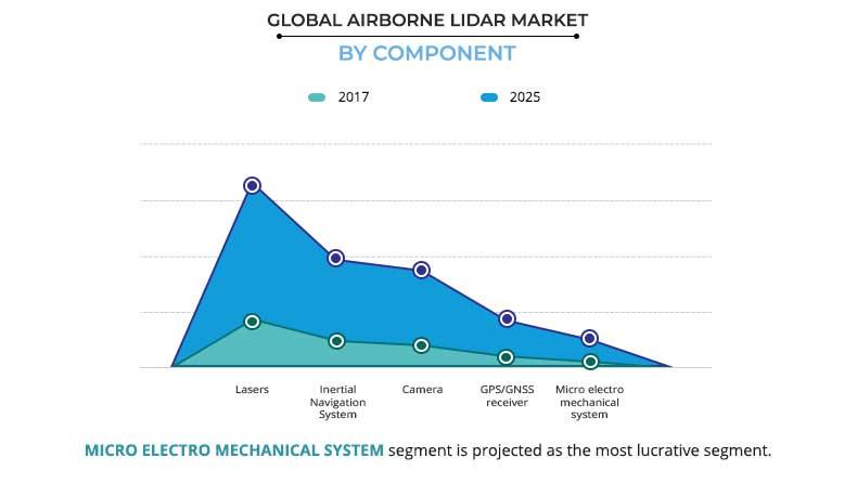
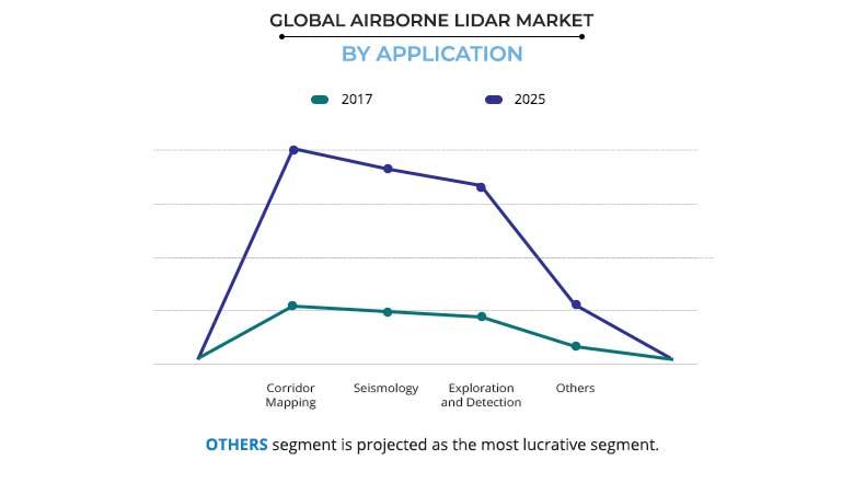
The airborne LiDAR market is segmented based on component, application, end-user, and region. Based on components, the market is divided into lasers, inertial navigation systems, cameras, GPS/GNSS receivers, and micro-electromechanical systems. Based on application, the market is categorized into corridor mapping, seismology, exploration & detection, and others. Based on end-user, the market is classified into defense & aerospace, civil engineering, archaeology, forestry & agriculture, transportation & logistics, and mining industry. Based on region, the market is analyzed across North America, Europe, Asia-Pacific, and LAMEA, along with their prominent countries.
Expansion in applications in defense and civil engineering
Government bodies are heavily investing in airborne LiDAR market applications for defense and civil engineering applications to increase the accuracy of operations and decrease the risk factors involved in these major industries. The need for unmanned air vehicles to reduce the loss of life on war fields, high precision of LiDAR-based monitoring, protection perimeters, and keeping locations under surveillance from the sky are the major factors that foster the growth in demand for airborne LiDAR for defense applications. Moreover, the airborne LiDAR market has witnessed an increased demand for infrastructure projects. The use of airborne LiDAR in all these projects and various government investments in defense are anticipated to fuel the overall airborne LiDAR market trends.
Low-cost drone-based imaging is one of the major factors that boost the growth of the global airborne LiDAR market. Drones provide high-precision 3D models at a very low cost compared to other competing technologies, such as airplanes and satellites. For instance, as per NASA, the cost of a Landsat 8 imaging satellite was around $300,000; however, an automated mapping drone such as sense Flys eBee RTK costs around $25,000. Moreover, drones for consumer and professional applications cost around $1,000. Apart from low cost, drones even render excellent results compared to the other two technologies. In the last five years, the price of commercial drones has witnessed a downfall owing to the reduced cost of its components and the surge in demand. Drones as a service, is one of the breakthroughs in the airborne LiDAR market owing to its reduced cost and capability to provide accurate height information mainly for 3D mapping applications.
The number of drones globally has increased by twofold in the past year. According to the annual report by Federal Aviation Administration (FAA), the number of drones in the U.S. has reached 2.5 million by the end of 2016. It is projected to reach up to 7.0 million by the end of 2020, out of which unmanned aerial vehicles are anticipated to be a whopping 4.3 million in number. All these factors are expected to fuel the development of airborne LiDAR; hence, the growth in the overall airborne LiDAR market is expected to grow in the future.
Potential Benefits for airborne LiDAR market:
- This report provides an in-depth analysis of the global airborne LiDAR market outlook along with current trends and future estimations to identify profitable investment opportunities
- Key drivers, opportunities, and restraints that shape the market along with their impact analysis are explained
- Porter's five forces analysis highlights the potency of buyers and suppliers to facilitate better business decisions for stakeholders and strengthen their supplier and buyer networks
- Market estimation of geographical regions is based on the current market scenario and future trends
Airborne LiDAR Market Report Highlights
| Aspects | Details |
| By Component |
|
| By Application |
|
| By End User |
|
| By Region |
|
| Key Market Players | RIEGL Laser Measurement Systems GmbH, Teledyne Technologies, Firmatek, Flir Systems, Inc., Saab Group, Merrick & Company, Faro Technologies, Inc., Leica Geosystems, Lasermap Inc., Airborne Imaging |
Analyst Review
Various government agencies and commercial users have witnessed an upsurge in the adoption of airborne LiDAR globally owing to low cost drone-based imaging. The number of the unmanned aerial vehicles (UAVs) has doubled in the past one year and is expected to witness notable growth in the future. Furthermore, innovations in the laser technology has reduced the cost of different airborne LiDAR products. In addition, change in demand and preference of industries has resulted in newer airborne LiDAR applications, apart from the conventional military applications.
Currently, drones have gained traction in different commercial usages as well. Therefore, increase in applications of airborne LiDAR in the commercial sector is expected to further supplement the growth of the global airborne LiDAR market. Sophistication of 3D imaging technology has fueled corridor mapping activities by the airborne LiDAR.
The market is expected to experience continued dominance from defense & aerospace compared to other industries such as mining, archaeology, and transportation & logistics. Various government agencies and commercial users are on a constant lookout for ways to replace traditional aerial photography methods such as helicopters with drones, to capture high-resolution images at a low cost. As helicopters are expensive and risky compared to drones, it has given airborne LiDAR a competitive edge over traditional aerial photography methods. The market is driven by the decline in price of drones, expansion of applications in defense & civil engineering, and rise in demand for 3D imaging.
The global airborne LiDAR market was valued at $316.2 million in 2017 and is projected to reach $1,010.5 million by 2025, registering a CAGR of 16.4% from 2018 to 2025. North America is expected to account for the highest revenue in the global market throughout the forecast period (2018–2025).
The major players operating in the global airborne LiDAR market are Teledyne Technologies, Saab Group, Airborne Imaging, Leica Geosystems, Faro Technologies, Inc., Flir Systems, Inc., RIEGL Laser Measurement Systems GmbH, Merrick & Company, Firmatek, and Lasermap Inc.
Loading Table Of Content...

